
 ...........................................................................................................


Subregion IId – Northern Aegean
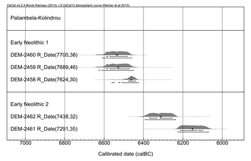
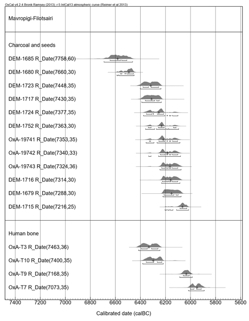
Until recently, the site with the most representative radiocarbon sequence in the western part of the northern Aegean (western and central Macedonia) was Nea Nikomedeia of the late 7th millennium BC. New sequences have been acknowledged from Paliambela-Kolindrou (Figure 1) and from Mavropigi-Filotsairi with single dates falling (according to the median values) into the middle of the 7th millennium BC (Figure 2). They are followed after a gap of up to two centuries by a new sequence of dates between 6300–6100/6000 BC (again estimated by the median values), belonging to the EN II. Pending their final publication only a very general appraisal of the two sites, Mavropigi in western and Paliambela in central Macedonia, is possible: they are antedating the sequence from Nea Nikomedeia and coincide with the beginning of the EN.
Nea Nikomedeia
Initially, the excavators conceived of Nea Nikomedeia as a two-layered site (Pyke 1996, 9 and Fig. 2.1), the c. 60–70 cm deep deposits being excavated in up to three spits of each c. 20 cm (Pyke 1996, 35, Table 2.1). Four samples from the EN (Q-655, GX-679, P-1202 and P-1203A) were analysed already in the early and mid-1960s (Figure 3), the two earliest of which support the (meanwhile refuted) opinion (Reingruber and Thissen 2009) that also in Macedonia the Neolithic started around or before 7000 BC. In the original report (based on the information given by the excavator R. J. Rodden) R. Stuckenrath assigns the two oldest dates as deriving "certainly from first building period"; the older Pennsylvania date is assigned to the "very probably first building period", and date P-1203A to the "probably first building period" although with some reservations. (Stuckenrath 1967, 335). According to C. Perlès (2001, 100–101, table 6.1) the three oldest mentioned dates should be contemporaneous and belonging to the first (lowest) building period EN1, but she rejects Q-655 and GX-679. The fourth date (P-1203A) was assigned by her to Phase EN2 (Perlès 2001, 104, table 6.1).

These four dates and also the group of new dates that were processed in 1988 and 1993 on bones and seeds (the OxA samples), making use of archive material from the original excavations, were published strictly according to their BP-age without any contextual information and without any indications according to phasing (Pyke & Yiouni 1996, 195). During the stratigraphical evaluation, G. Pyke was able to discern on behalf of overlapping foundation trenches three building levels and nine groups of houses (Pyke 1996, 9–52). The total duration of the settlement has been estimated to cover between 50 and 150 years (Pyke 1996, 47–48; Yiouni 1996, 184). This appraisal is not supported by the radiocarbon dates that are of good quality, on short-lived samples, dated after 1988: according to the median values they do span at least a duration of 500 years. Part of the problem might be the wiggles in the calibration curve affecting virtually all dates from the sequence (Figure 4). This dilemma certainly cannot be solved without knowledge of the stratigraphical context of the dates. We are looking forward to receiving more information concerning the provenance of the samples in the envisaged publication presenting the small finds from this site.
At first sight, the AMS-radiocarbon dates corroborate the separation into three datable clusters: the oldest dates (the combined dates OxA-1605 + OxA-4282, date OxA-3876 and OxA-3874) are falling between 6350 and 6250 BC; a group of five dates is covering the 62nd century BC, and the youngest combined date (OxA-1603 + OxA-4280) results shortly after 6000 calBC. Nea Nikomedeia could thus indeed be considered as an exclusively EN site without any evidence for the MN (Pyke 1996, 48). Alternatively, the R_combined date OxA-1603 + OxA-4280 with a median value at 5900 calBC would point at a continuation of the habitation into the early MN.

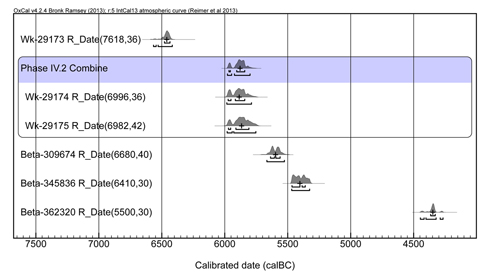
From the eastern part of the northern Aegean region, in Greek (West Thrace) and Turkish (East) Thrace, sites of the mid-7th-millennium are still missing. Yet recently, from Uğurlu, on the island of Gökçeada/Imbros, new radiocarbon dates were reported. The two dates from Phase IV display a similar early 6th millennium cal BC range as Hoca Çeşme Phase III when combined, using the Combine command (Figure 5). The pottery as published from Uğurlu IV seems more or less identical to the assemblage from Hoca Çeşme III. Given the strong continuity between basal Uğurlu (Phase V) and IV, the single very early date from V (Wk-29173) might be an outlier, pending the arrival of new dates for this phase.
Hoca Çeşme
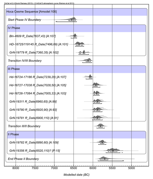
From Hoca Çeşme in the Maritsa/Meriç Delta a sequence of 14 dates obtained on unidentified charcoal covers the periods of the EN and MN, roughly between 6500 and 5500 calBC (according to median values). In the boundary model (Figure 6) three of the Groningen dates (GrN-19355, GrN-19357 and GrN-19310) have not been included since they present very large standard deviations due to a low amount of carbon (pers. comm. J. van der Plicht).
Phase III has the most consistent series, the modelled dates clustering between 6000–5800 cal BC at 1σ. The single Phase II date is consistent with phase III (in earlier publications this date was in fact assigned to Phase III, cf. Özdoğan 1997). The three dates from Phase IV spread widely between 6500–6200 and suggest a gap between Phase IV and III, which is however bridged by single date HD-16724-17186, assigned to Phase III. These dates are difficult to reconcile with the image of continuity demonstrated between Phase IV and III, both in terms of pottery, and regarding the architecture, and use of a defence wall (cf. Özdoğan 1999, Karul & Bertram 2005).
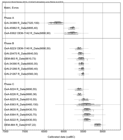
Makri (Evros)
Potentially containing contemporaneous, though non-excavated deposits, the site of Makri (Figure 7), west of Hoca Çeşme, may have been part of the same settling event as were Hoca Çeşme and Uğurlu. Beginning and end of the sequence in Makri are marked by outliers, the very early date GrA-34389 was of 'low carbon yield' and needs further confirmation (Nikos Efstratiou, pers. comm. 25 August 2015). According to median values the occupation started in the developed MN with Phase A at 5800 calBC and ended after 5500 calBC with Phase C in the LN.
General assessment
In the northern Aegean were the levels bearing evidence of earliest farming activities followed by gaps, the sequences continuing again only after one or even two centuries. This is the case both in the western part (Mavropigi and Paliambela) as well as in the eastern part of Region II (Uğurlu V and possibly Hoca Çeşme IV). Interestingly, a similar situation is also met at other sites of the Aegean (Ulucak and Çukuriçi Höyük in the eastern Aegean, Knossos and Franchthi Cave in the southern Aegean). One explanation might be that at the transition from the Mesolithic to the Neolithic (see Analysis) the communities living in and exploring the Aegean were still very mobile. Only after the subsequent generations settled for a specific location did magoules form, the most famous ones being those in the area of Thessaly.
1. Western and Central Macedonia
Paliambela-Kolindrou and MavropigiUntil recently, the site with the most representative radiocarbon sequence in the western part of the northern Aegean (western and central Macedonia) was Nea Nikomedeia of the late 7th millennium BC. New sequences have been acknowledged from Paliambela-Kolindrou (Figure 1) and from Mavropigi-Filotsairi with single dates falling (according to the median values) into the middle of the 7th millennium BC (Figure 2). They are followed after a gap of up to two centuries by a new sequence of dates between 6300–6100/6000 BC (again estimated by the median values), belonging to the EN II. Pending their final publication only a very general appraisal of the two sites, Mavropigi in western and Paliambela in central Macedonia, is possible: they are antedating the sequence from Nea Nikomedeia and coincide with the beginning of the EN.
—A.R.
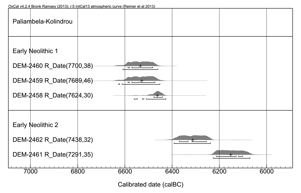
Figure 1. Calibrated dates from the Early Neolithic levels of Paliambela-Kolindrou

Figure 2. Calibrated dates from Mavropigi-Filotsairi
 up
upNea Nikomedeia
Initially, the excavators conceived of Nea Nikomedeia as a two-layered site (Pyke 1996, 9 and Fig. 2.1), the c. 60–70 cm deep deposits being excavated in up to three spits of each c. 20 cm (Pyke 1996, 35, Table 2.1). Four samples from the EN (Q-655, GX-679, P-1202 and P-1203A) were analysed already in the early and mid-1960s (Figure 3), the two earliest of which support the (meanwhile refuted) opinion (Reingruber and Thissen 2009) that also in Macedonia the Neolithic started around or before 7000 BC. In the original report (based on the information given by the excavator R. J. Rodden) R. Stuckenrath assigns the two oldest dates as deriving "certainly from first building period"; the older Pennsylvania date is assigned to the "very probably first building period", and date P-1203A to the "probably first building period" although with some reservations. (Stuckenrath 1967, 335). According to C. Perlès (2001, 100–101, table 6.1) the three oldest mentioned dates should be contemporaneous and belonging to the first (lowest) building period EN1, but she rejects Q-655 and GX-679. The fourth date (P-1203A) was assigned by her to Phase EN2 (Perlès 2001, 104, table 6.1).
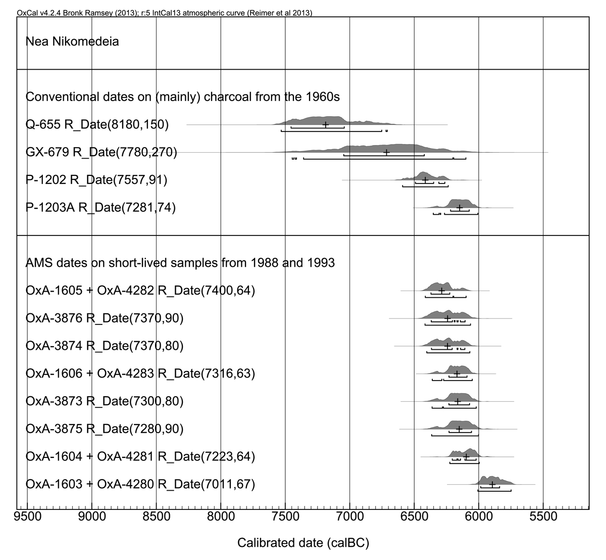
Figure 3. Calibrated dates from Nea Nikomedeia arranged according to their ages.
These four dates and also the group of new dates that were processed in 1988 and 1993 on bones and seeds (the OxA samples), making use of archive material from the original excavations, were published strictly according to their BP-age without any contextual information and without any indications according to phasing (Pyke & Yiouni 1996, 195). During the stratigraphical evaluation, G. Pyke was able to discern on behalf of overlapping foundation trenches three building levels and nine groups of houses (Pyke 1996, 9–52). The total duration of the settlement has been estimated to cover between 50 and 150 years (Pyke 1996, 47–48; Yiouni 1996, 184). This appraisal is not supported by the radiocarbon dates that are of good quality, on short-lived samples, dated after 1988: according to the median values they do span at least a duration of 500 years. Part of the problem might be the wiggles in the calibration curve affecting virtually all dates from the sequence (Figure 4). This dilemma certainly cannot be solved without knowledge of the stratigraphical context of the dates. We are looking forward to receiving more information concerning the provenance of the samples in the envisaged publication presenting the small finds from this site.
At first sight, the AMS-radiocarbon dates corroborate the separation into three datable clusters: the oldest dates (the combined dates OxA-1605 + OxA-4282, date OxA-3876 and OxA-3874) are falling between 6350 and 6250 BC; a group of five dates is covering the 62nd century BC, and the youngest combined date (OxA-1603 + OxA-4280) results shortly after 6000 calBC. Nea Nikomedeia could thus indeed be considered as an exclusively EN site without any evidence for the MN (Pyke 1996, 48). Alternatively, the R_combined date OxA-1603 + OxA-4280 with a median value at 5900 calBC would point at a continuation of the habitation into the early MN.
—A.R. / L.T.
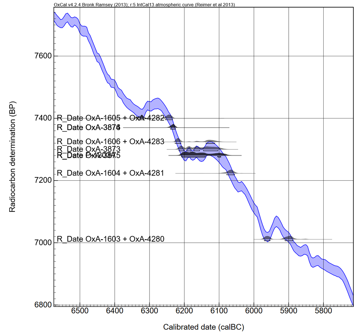
Figure 4. Calibrated dates from Nea Nikomedeia plotted on the calibration curve.
2. Eastern Macedonia, Aegean Thrace and the northern Aegean islands
UğurluFrom the eastern part of the northern Aegean region, in Greek (West Thrace) and Turkish (East) Thrace, sites of the mid-7th-millennium are still missing. Yet recently, from Uğurlu, on the island of Gökçeada/Imbros, new radiocarbon dates were reported. The two dates from Phase IV display a similar early 6th millennium cal BC range as Hoca Çeşme Phase III when combined, using the Combine command (Figure 5). The pottery as published from Uğurlu IV seems more or less identical to the assemblage from Hoca Çeşme III. Given the strong continuity between basal Uğurlu (Phase V) and IV, the single very early date from V (Wk-29173) might be an outlier, pending the arrival of new dates for this phase.
—L.T.
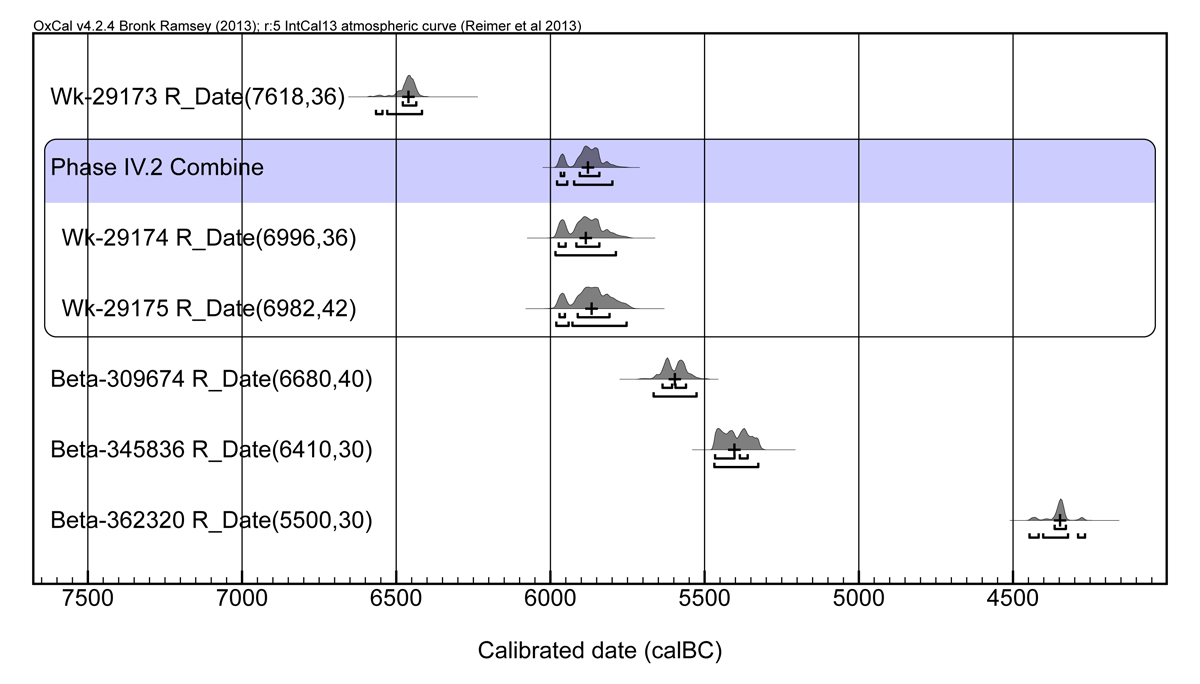
Figure 5. Uğurlu dates. The Phase IV.2 combination (Acomb=119.7%) yields a 1σ range of 5970–5840 cal BC.
Hoca Çeşme
From Hoca Çeşme in the Maritsa/Meriç Delta a sequence of 14 dates obtained on unidentified charcoal covers the periods of the EN and MN, roughly between 6500 and 5500 calBC (according to median values). In the boundary model (Figure 6) three of the Groningen dates (GrN-19355, GrN-19357 and GrN-19310) have not been included since they present very large standard deviations due to a low amount of carbon (pers. comm. J. van der Plicht).
Phase III has the most consistent series, the modelled dates clustering between 6000–5800 cal BC at 1σ. The single Phase II date is consistent with phase III (in earlier publications this date was in fact assigned to Phase III, cf. Özdoğan 1997). The three dates from Phase IV spread widely between 6500–6200 and suggest a gap between Phase IV and III, which is however bridged by single date HD-16724-17186, assigned to Phase III. These dates are difficult to reconcile with the image of continuity demonstrated between Phase IV and III, both in terms of pottery, and regarding the architecture, and use of a defence wall (cf. Özdoğan 1999, Karul & Bertram 2005).
—L.T.
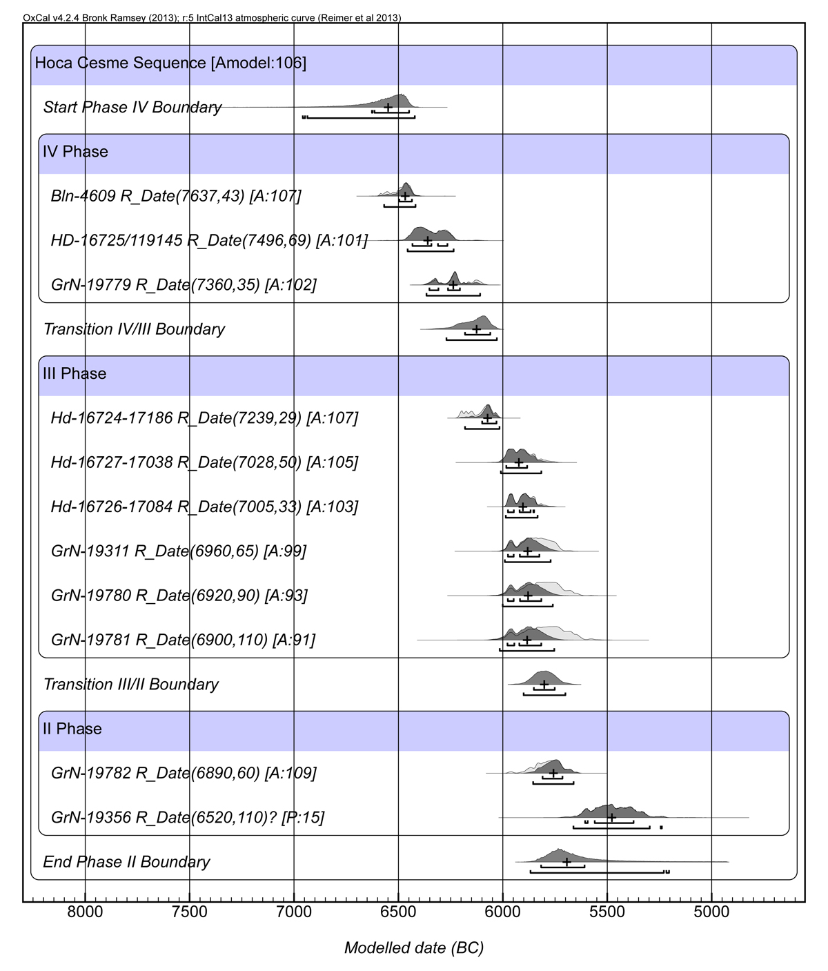
Figure 6. Hoca Çeşme boundary model. Phase II date GrN-19356 treated as an outlier, but is probably an intrusion from overlying Phase I.
Makri (Evros)
Potentially containing contemporaneous, though non-excavated deposits, the site of Makri (Figure 7), west of Hoca Çeşme, may have been part of the same settling event as were Hoca Çeşme and Uğurlu. Beginning and end of the sequence in Makri are marked by outliers, the very early date GrA-34389 was of 'low carbon yield' and needs further confirmation (Nikos Efstratiou, pers. comm. 25 August 2015). According to median values the occupation started in the developed MN with Phase A at 5800 calBC and ended after 5500 calBC with Phase C in the LN.
—A.R.

Figure 7. Calibrated dates from Makri, Evros, West Thrace, arranged according to phases and ages.
General assessment
In the northern Aegean were the levels bearing evidence of earliest farming activities followed by gaps, the sequences continuing again only after one or even two centuries. This is the case both in the western part (Mavropigi and Paliambela) as well as in the eastern part of Region II (Uğurlu V and possibly Hoca Çeşme IV). Interestingly, a similar situation is also met at other sites of the Aegean (Ulucak and Çukuriçi Höyük in the eastern Aegean, Knossos and Franchthi Cave in the southern Aegean). One explanation might be that at the transition from the Mesolithic to the Neolithic (see Analysis) the communities living in and exploring the Aegean were still very mobile. Only after the subsequent generations settled for a specific location did magoules form, the most famous ones being those in the area of Thessaly.
—A.R.