
 .................................................................................................................................................


Region II – The Aegean
Geography
In a circum-Aegean perspective, we take Region II not only to include the Aegean Sea with its islands but also all areas close to the sea (Figure 1): The outer boundaries are given by the frame of the different surrounding mountains:
- towards the east the Aegean area is bordered by the Anatolian Plateau between the Uludağ (in the north) and the Western Taurus (in the south);
- the southern limit is formed by the chain of islands east and west of Crete;
- towards the west the Aegean is limited by the chains of the Taygetos and Parnos (on the Peloponnese) and the Pindus Mountain range (of central and northern Greece);
- the north is confined by the chains of different massifs between Mount Olympus and the Rhodopes (with the Mountains Vermio, Voras and Orvilos in between).
Northern and southern limits are additionally supported by the climatic division as given by Huggett for the Mediterranean subtropical zone (Huggett 2004, 102 and fig. 6.9).

Figure 1. The circum-Aegean (Region II) with main seas, mountains, gulfs and rivers
For the inner separation, we follow Vacchi et al. 2013. The fault lines that continue from the continental shelf into the Aegean Sea (Figure 2) indicate not only the spatial extent of the plates but also the geographical relevant groups of islands (especially near the Anatolian coast) and the boundaries between the main subregions (both in mainland Greece and in mainland Anatolia).
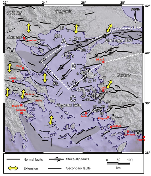
Figure 2. Fault lines in the Aegean Basin with the "South Marmara microplate" (white dashes) between the "North Anatolian Trench" (NAT), the "North Anatolian Basin" (NAB), the "Skyros Trough" (ST) and the "Lesvos Psara Trough" (LPT) – (adapted from Vacchi et al. 2013, Fig. 1)
According to the four cardinal points we distinguish (clockwise) between:
IIa. The eastern Aegean
In the east the upper valleys of the E–W flowing rivers (foremost the Gediz, Küçük Menderes and Büyük Menderes) originating in the western parts of the Taurus Mountains are linking the Aegean area to the Lake District of Southwest Anatolia. Many of the offshore islands, some of which were part of the landmass before the rise in sea level during the early Holocene, belong to this area. More precisely, the islands between the fault line near Edremit in the north and the line south of Ikaria and Samos are thus part of the eastern Aegean (i.e., the islands of Lesbos, Chios, Samos and Ikaria, also known as Νησιά Βορείου Αιγαίου – the "Islands of the Northern Aegean"). The Anatolian coastal area is characterised by many gulfs and bays (from southwest to north: the bays of Fethiye, Marmaris, Gökova, and Bodrum, the Göllük or Mandalya Körfezi, the Kuşadası Gulf, and the gulfs of İzmir, Çandarlı and Edremit).
IIb. The southern Aegean
The southern Aegean, consisting mainly of islands and peninsulas, in its southern limits forms an arc starting in the east between the Akdağları of the Western Taurus (and the river Eşen Çayı), continuing through the chains of islands Rhodos – Karpathos – Kasos and Crete up to Antikythera and Kythera in the west. This arc is "doubled" by the "South Aegean Volcanic Arc" including the volcanoes of Methana, Milos, Santorini and Nisyros. On the Peloponnese the western boundary of this subregion is given by the Taygetos and the Arkadian mountain range that connect towards the north to the Pindus. The coastal landscape is divided into many bays, among them the Argolic (Argive) Gulf, the Saronic Gulf, the Corinthian Gulf and the Petalioi Gulf (between Attica and Southern Euboea). This latter bay is defining the northwest boundary of the subregion. The northern, permeable, boundary is given by the islands of Andros – Tinos – Mykonos, this NW–SE line continuing towards the peninsula of Bodrum, with the islands of the Dodecanese and the Southern Sporades in between.
IIc. The western Aegean
The Pindus mountain range is dividing Central Greece (Sterea Ellada) into a western (Ionian) and an eastern (Aegean) part. The latter, here labelled as western Aegean Region, is comprised between the mountains of Cithaeron (or Kithairon) and Xtipas (near Chalcis) as its southern limits, and Mount Olympus and, roughly, the Aliakmon river as its northern boundaries.
The western Aegean is characterised by a multitude of mountains and valleys that break this subregion up into several smaller areas: the W–E flowing Spercheios River and the deep indentation of the bay of Maliakos divide this subregion into a southern and a northern part, with the Phthiotida shared by both. The plain of the northern Phthiotis (around Domokos) is part of the Thessalian plain. This plain is further separated by a NW–SE oriented ridge of lower elevation, the Revenia hills, into a western and an eastern part that are, nonetheless, connected by the Pinios River.
The southern areas of the Phthiotida are blending near the Kifissos River into the landscapes of Locris, Phocis and Boeotia (the southern areas of Central Greece). The coastal areas are also in this region characterised by gulfs and bays, like the Euboean Gulf or the Pagasetic Gulf. To this region belong also the Northern Sporades, Skyros and the northern part of Euboea.
IId. The northern Aegean
The northern Aegean, east of the Pindos in the west to the Dardanelles in the east, is in its western portion dominated by the Thermaic Gulf and important rivers flowing into it (Aliakmon, Axios, Loudias, Gallikos – see Figure 3). Separated by the peninsula of the Chalkidiki of Central Macedonia, the eastern part of this subregion is cut by the river valleys of the Strymon, Nestos and Evros and by the Dardanelles. Together with the Strymonian or Strymonic Gulf, the Gulf of Kavala and the Gulf of Saros north of the Gallipoli Peninsula are facing the islands of Thasos, Samothrace, Gökceada and Lemnos. Its southernmost tip, Cape Baba with Babakale, is merging into the Anatolian-Aegean Subregion IIa. The South Marmara microplate together with the North Anatolian Basin (see Figure 2) are part of the northern Aegean.
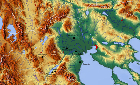
Figure 3. Map of western Macedonia with main mountains and rivers
Sites (n=84)
| IIa: Eastern Aegean | IIb: Southern Aegean | IIc: Western Aegean | IId: Northern Aegean |
| Aphrodisias-Pekmez | Agios Giorgios Cave, Kalythies | Achilleion | Axos-Pellas |
| Beycesultan | Franchthi Cave | Agia Triada | Beşik-Sivritepe |
| Çukuriçi Höyük | Franchthi, Koilada Bay | Agios Petros | Dikili Tash |
| Ege Gübre | Girmeler | Argissa Magoula | Dimitra |
| Kerame 1 | Halieis | Chaironeia | Dispilio |
| Ulucak Höyük | Kastria (Kalavryta) | Corycian Cave | Giannitsa B |
| Yeşilova Höyük | Kephala on Kea | Cyclops Cave-Youra | Hoca Çeşme |
| Kitsos Cave | Dimini | Kasiani | |
| Klisoura, cave 1 | Elateia | Kastri Theologos | |
| Knossos | Halai | Kleitos | |
| Koumelo Cave, Rhodos | Imvrou Pigadi | Krovili | |
| Kouphovouno | Makrychori | Kryoneri | |
| Kouveleiki Cave A | Mandra | Kumtepe | |
| Kouveleiki Cave B | Mikrothives | Lafrouda | |
| Maroulas | Otzaki | Lefkopetra | |
| Saliagos | Palioskala | Limenaria | |
| Pevkakia | Makri | ||
| Plastiras Lake | Mandalo | ||
| Platia Magoula Zarkou | Mavropigi | ||
| Prodromos | Megalo Nisi Galanis | ||
| Proskynas | Nea Nikomedeia | ||
| Rachmani | Orfeas Alistratis | ||
| Sarakenos | Paliambela | ||
| Sesklo | Pontokomi-Vrissi | ||
| Skoteini Cave-Tharrounia | Revenia | ||
| Sykeon | Roditis | ||
| Theopetra | Servia | ||
| Vasilis-Farsala | Servia-Varytimides | ||
| Sitagroi | |||
| Sosandra | |||
| Uğurlu | |||
| Varemenoi-Goulon | |||
| Xirolimni-Porta |
Geography
In a circum-Aegean perspective, we take Region II not only to include the Aegean Sea with its islands but also all areas close to the sea (Figure 1): The outer boundaries are given by the frame of the different surrounding mountains:
- towards the east the Aegean area is bordered by the Anatolian Plateau between the Uludağ (in the north) and the Western Taurus (in the south);
- the southern limit is formed by the chain of islands east and west of Crete;
- towards the west the Aegean is limited by the chains of the Taygetos and Parnos (on the Peloponnese) and the Pindus Mountain range (of central and northern Greece);
- the north is confined by the chains of different massifs between Mount Olympus and the Rhodopes (with the Mountains Vermio, Voras and Orvilos in between).
Northern and southern limits are additionally supported by the climatic division as given by Huggett for the Mediterranean subtropical zone (Huggett 2004, 102 and fig. 6.9).
 up
up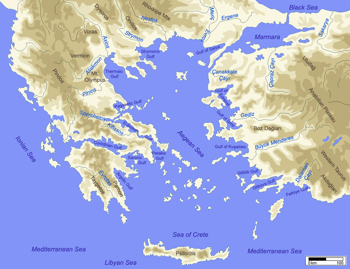
Figure 1. The circum-Aegean (Region II) with main seas, mountains, gulfs and rivers
For the inner separation, we follow Vacchi et al. 2013. The fault lines that continue from the continental shelf into the Aegean Sea (Figure 2) indicate not only the spatial extent of the plates but also the geographical relevant groups of islands (especially near the Anatolian coast) and the boundaries between the main subregions (both in mainland Greece and in mainland Anatolia).
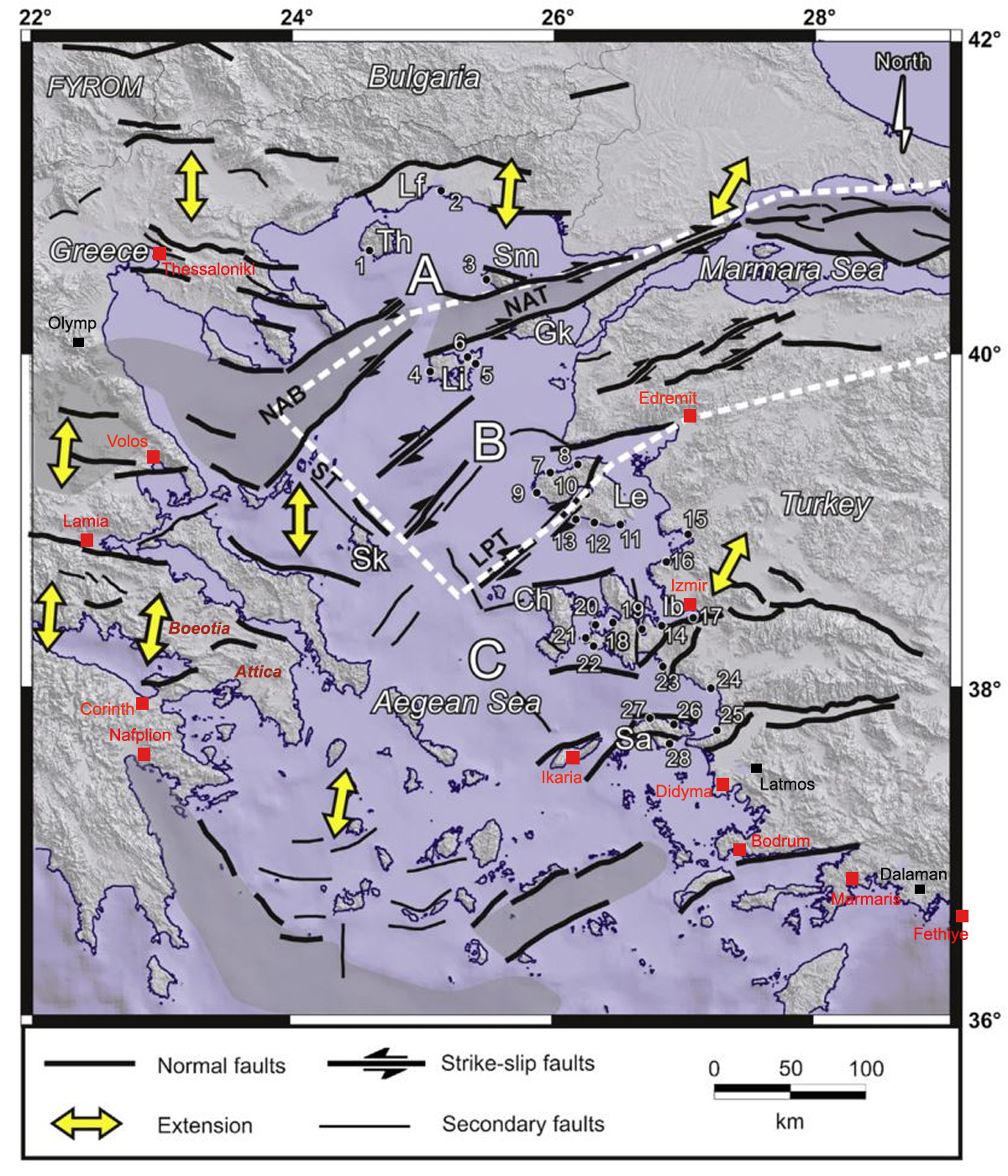
Figure 2. Fault lines in the Aegean Basin with the "South Marmara microplate" (white dashes) between the "North Anatolian Trench" (NAT), the "North Anatolian Basin" (NAB), the "Skyros Trough" (ST) and the "Lesvos Psara Trough" (LPT) – (adapted from Vacchi et al. 2013, Fig. 1)
According to the four cardinal points we distinguish (clockwise) between:
IIa. The eastern Aegean
In the east the upper valleys of the E–W flowing rivers (foremost the Gediz, Küçük Menderes and Büyük Menderes) originating in the western parts of the Taurus Mountains are linking the Aegean area to the Lake District of Southwest Anatolia. Many of the offshore islands, some of which were part of the landmass before the rise in sea level during the early Holocene, belong to this area. More precisely, the islands between the fault line near Edremit in the north and the line south of Ikaria and Samos are thus part of the eastern Aegean (i.e., the islands of Lesbos, Chios, Samos and Ikaria, also known as Νησιά Βορείου Αιγαίου – the "Islands of the Northern Aegean"). The Anatolian coastal area is characterised by many gulfs and bays (from southwest to north: the bays of Fethiye, Marmaris, Gökova, and Bodrum, the Göllük or Mandalya Körfezi, the Kuşadası Gulf, and the gulfs of İzmir, Çandarlı and Edremit).
IIb. The southern Aegean
The southern Aegean, consisting mainly of islands and peninsulas, in its southern limits forms an arc starting in the east between the Akdağları of the Western Taurus (and the river Eşen Çayı), continuing through the chains of islands Rhodos – Karpathos – Kasos and Crete up to Antikythera and Kythera in the west. This arc is "doubled" by the "South Aegean Volcanic Arc" including the volcanoes of Methana, Milos, Santorini and Nisyros. On the Peloponnese the western boundary of this subregion is given by the Taygetos and the Arkadian mountain range that connect towards the north to the Pindus. The coastal landscape is divided into many bays, among them the Argolic (Argive) Gulf, the Saronic Gulf, the Corinthian Gulf and the Petalioi Gulf (between Attica and Southern Euboea). This latter bay is defining the northwest boundary of the subregion. The northern, permeable, boundary is given by the islands of Andros – Tinos – Mykonos, this NW–SE line continuing towards the peninsula of Bodrum, with the islands of the Dodecanese and the Southern Sporades in between.
IIc. The western Aegean
The Pindus mountain range is dividing Central Greece (Sterea Ellada) into a western (Ionian) and an eastern (Aegean) part. The latter, here labelled as western Aegean Region, is comprised between the mountains of Cithaeron (or Kithairon) and Xtipas (near Chalcis) as its southern limits, and Mount Olympus and, roughly, the Aliakmon river as its northern boundaries.
The western Aegean is characterised by a multitude of mountains and valleys that break this subregion up into several smaller areas: the W–E flowing Spercheios River and the deep indentation of the bay of Maliakos divide this subregion into a southern and a northern part, with the Phthiotida shared by both. The plain of the northern Phthiotis (around Domokos) is part of the Thessalian plain. This plain is further separated by a NW–SE oriented ridge of lower elevation, the Revenia hills, into a western and an eastern part that are, nonetheless, connected by the Pinios River.
The southern areas of the Phthiotida are blending near the Kifissos River into the landscapes of Locris, Phocis and Boeotia (the southern areas of Central Greece). The coastal areas are also in this region characterised by gulfs and bays, like the Euboean Gulf or the Pagasetic Gulf. To this region belong also the Northern Sporades, Skyros and the northern part of Euboea.
IId. The northern Aegean
The northern Aegean, east of the Pindos in the west to the Dardanelles in the east, is in its western portion dominated by the Thermaic Gulf and important rivers flowing into it (Aliakmon, Axios, Loudias, Gallikos – see Figure 3). Separated by the peninsula of the Chalkidiki of Central Macedonia, the eastern part of this subregion is cut by the river valleys of the Strymon, Nestos and Evros and by the Dardanelles. Together with the Strymonian or Strymonic Gulf, the Gulf of Kavala and the Gulf of Saros north of the Gallipoli Peninsula are facing the islands of Thasos, Samothrace, Gökceada and Lemnos. Its southernmost tip, Cape Baba with Babakale, is merging into the Anatolian-Aegean Subregion IIa. The South Marmara microplate together with the North Anatolian Basin (see Figure 2) are part of the northern Aegean.

Figure 3. Map of western Macedonia with main mountains and rivers